

Introduction: The Data Dilemma in Earth Observation
Over fifty years since the first Landsat satellite, the planet is awash in an unprecedented flood of Earth observation (EO) data from satellites, radar, climate simulations, and in-situ measurements. Yet, a persistent problem remains: while data acquisition accelerates, high-quality, globally distributed ground-truth labels are scarce and expensive to obtain. This scarcity limits our ability to quickly and accurately map critical planetary variables like crop type, forest loss, water resources, or disaster impacts, especially at fine spatial and temporal resolution.
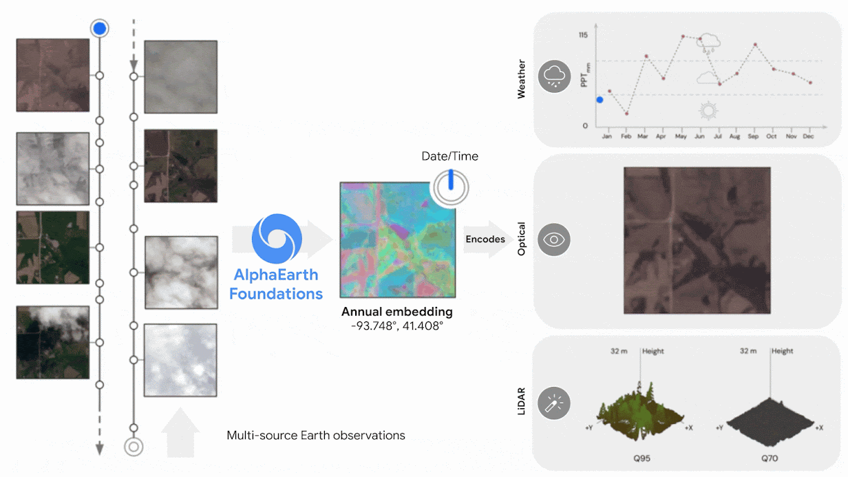
Meet AlphaEarth Foundations (AEF): The “Virtual Satellite”
Google DeepMind introduces AlphaEarth Foundations (AEF), a breakthrough geospatial AI model that directly addresses these scaling, efficiency, and data scarcity problems. Rather than acting as a traditional satellite sensor, AEF operates as what DeepMind dubs a “virtual satellite”: an artificial intelligence system that stitches together petabytes of EO data from diverse sources—optical images, radar, LiDAR, digital elevation models, environmental data, geotagged text, and more—into a unified, compact, and information-rich geospatial “embedding field”.
These embedding fields are annual, global layers—each 10m×10m in resolution—that summarize the most salient features and changes of every observed location on Earth, for every year since 2017. Unlike waiting for the next satellite flyover or wrestling with incomplete or cloud-obscured imagery, AEF can generate up-to-date, analysis-ready maps on demand, filling in gaps and extrapolating insights even in regions with missing or highly sparse data.
Technical Innovation: From Sparse Labels to Dense, General Purpose Maps
Embedding Field Model and Compression
At its core, AEF introduces a novel embedding field model. Instead of treating satellite images, sensor readings, and field measurements as isolated datapoints, the model learns to encode and integrate these multimodal, multi-temporal sources into a dense “embedding” for each 10m² parcel of land. Each embedding is a short, 64-byte vector summarizing the local landscape, climate, vegetation state, land use, and more—across time and sensor modalities.
Through advanced self-supervised and contrastive learning, AEF not only reconstructs the past and present but also interpolates or extrapolates to synthesize coherent maps for periods or locations with missing measurements. The embeddings are so information-dense that they require 16× less storage than the most compact traditional AI alternatives, without loss of accuracy—a vital feature for planetary-scale mapping.
Space-Time Precision Architecture
To translate such variety and volume of raw EO data into meaningful, consistent summaries, AEF employs a bespoke neural architecture called “Space Time Precision” (STP)1. STP operates simultaneously along spatial, temporal, and resolution axes:
- Spatial path: ViT-like attention encodes local patterns (landforms, infrastructure, landcover).
- Temporal path: Specialized attention layers aggregate sensor data over arbitrary time windows, enabling fine-grained, continuous time conditioning.
- Precision path: Hierarchical, multi-resolution convolutional blocks maintain sharp details while summarizing over larger contexts.
- Auxiliary paths: Geo-tagged text (e.g., Wikipedia, GBIF occurrences) add semantic and physical labels, anchoring the mapping to real-world knowledge.
Each subnetwork is regularly exchanged through pyramid “cross-talks,” ensuring both localized and global context are retained. The result: highly resolved, robust, and consistent embedding fields—even for locations and periods never directly observed in the training data.
Robustness to Missing and Noisy Data
A key innovation is AEF’s dual-model training (teacher-student consistency), which simulates dropped or missing input sources during learning. This ensures the model produces reliable outputs regardless of which sensors happen to be available for inference—a crucial property for persistent global monitoring.
Scientific Performance: Benchmarks and Real-World Utility
Outperforming the State-of-the-Art
AlphaEarth Foundations has been rigorously tested against both classic hand-designed features (spectral indices, temporal harmonics, composites) and leading ML-based models (SatCLIP, Prithvi, Clay) across 15 challenging mapping tasks:
- Classification (land cover, crop type, tree species, etc.)
- Regression (evapotranspiration, emissivity)
- Change detection (deforestation, land use transitions, urban growth, etc.)
On average, AEF reduced error rates by about 24% compared to the next-best solution across all tasks—most dramatically for annual land cover, land use, crop mapping, and evapotranspiration, where other models often struggled or failed to generate meaningful results. In extreme low-shot scenarios (1–10 labeled samples per class), AEF still performed best or on par with expert-tuned, domain-specific models.
Notably, AEF is the first EO representation to support continuous time: practitioners can generate maps for any date range, not just for discrete scenes or “windows.”
Use Cases and Deployment
Thanks to its speed, compactness, and open data release, AEF is already being used by:
- Governments and NGOs to monitor agriculture, illegal logging, deforestation, and urban expansion (e.g., the UN FAO, MapBiomas in Brazil, Group on Earth Observations).
- Scientists and conservationists to map previously uncataloged ecosystems and track subtle environmental dynamics (e.g., sand dune migration, grassland loss, wetland changes).
- Planners and the public to access high-quality, real-time maps for disaster response, drought planning, biodiversity research, and infrastructure visualization with minimal technical resources and no need for GPU-intensive, bespoke model training.
The global, annual embedding layers are hosted in Google Earth Engine, making them easily accessible to practitioners worldwide.
Impact and Future Directions
AEF’s model-as-data approach marks a paradigm shift in EO science: instead of repeatedly training bespoke models on limited data, practitioners gain general-purpose, information-rich summaries tailorable to any task—speeding up science, levelling the playing field for smaller organizations, and supporting real-time, proactive decision-making at all geographic scales.
Key future opportunities include:
- Expansion to finer spatial and temporal resolutions as sensor networks and EO data volume further explode.
- Even deeper integration with text, field observations, and crowd-sourced data, enabling dynamic global “Earth twins” that fuse measurements with local and historical knowledge.
- Model improvements for robustness to adversarial, rare, or novel scenarios, ensuring continued relevance as environments and sensors evolve.
Conclusion
AlphaEarth Foundations is not merely another “AI model,” but a foundational infrastructure for the geospatial sciences—bridging the gap between the deluge of orbital data and actionable, equitable environmental intelligence. By compressing petabytes into performant, general-purpose embedding fields, Google DeepMind has laid the groundwork for a more transparent, measurable, and responsive relationship with our planetary home.
Check out the Paper and DeepMind Blog. All credit for this research goes to the researchers of this project. Also, feel free to follow us on Twitter and don’t forget to join our 100k+ ML SubReddit and Subscribe to our Newsletter.
You may also like NVIDIA’s Open Sourced Cosmos DiffusionRenderer [Check it now]
Asif Razzaq is the CEO of Marktechpost Media Inc.. As a visionary entrepreneur and engineer, Asif is committed to harnessing the potential of Artificial Intelligence for social good. His most recent endeavor is the launch of an Artificial Intelligence Media Platform, Marktechpost, which stands out for its in-depth coverage of machine learning and deep learning news that is both technically sound and easily understandable by a wide audience. The platform boasts of over 2 million monthly views, illustrating its popularity among audiences.